HOW KAZAKHSTANIS “VOTE WITH THEIR FEET”
- Jun 13, 2025
- 2 min read

Data scientist
“Everyone is leaving the country,” “everyone is moving to Almaty/Astana.” But what is the real situation with migration? We analyzed the movement of people across 227 cities and districts of the country — both within all domestic regions and abroad — for the year 2024. We filtered only significant flows and clustered them.
What did we discover?
1. The main migration flows occur within the country, not outside it. Even in the northern border regions, migration is toward the regional centers.
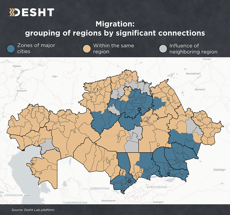
2. The majority of migration happens within regions, i.e., from rural districts to the regional center. Even Astana and Almaty do not significantly affect this pattern.
On the map, these territories are marked in yellow.
3. The three major cities — Almaty, Astana and Shymkent — have their own zones of migrant attraction. These are marked in blue on the map.
Interestingly, these cities do not compete for people — each has its own migration radius, with no overlaps.
- Astana. Its zone of influence covers almost all of Akmola region, as well as Ekibastuz in Pavlodar region, Nura district of Karaganda region and the lower districts of Kostanay region, including Arkalyk.
In the future, it seems reasonable to consider creating a separate peri-capital region, similar to how Almaty region was divided.
- Almaty city and Almaty region. They are grouped due to the strong agglomeration of the metropolis. Its zone of influence includes all of Zhetysu region, eastern Zhambyl and the lower part of Abay region.
- Shymkent remains, for now, a center only for Turkistan region.
4. The “contested” territories — areas that actively migrate to neighboring regions — are marked in gray.
The most vivid case: the 5 lower districts of North Kazakhstan region, which are more oriented toward Kokshetau. For example, in the case of Aiyrtau district, its migration balance with neighboring Akmola is 6 times higher than with its own North Kazakhstan region. The distance to Kokshetau is 90 km, while to Petropavl — 220 km.
A similar example: Zhanaarka district and the Karazhal city in Ulytau region, which are more strongly linked with Karaganda region.
Other cases:
Kokpekty and Zharma districts — between their own Abay region and East Kazakhstan region.
Zharkain district — between its own Akmola region, Kostanay region and Astana.
Zhylyoi district — between its own Atyrau region and neighboring Aktobe region.
All of this vividly demonstrates the power of the laws of economic geography.